News & announcements
Saving your history
Early accounts
Maps
Nearby towns
People
Churches
Schools
Municipal
Organizations
Businesses
The mines
Transportation
Streets
Buildings
Entertainment
Celebrations
Sports
Ethnic groups
1895 Sanborn map of Freeland, Pa.
What's on this page about Freeland:
- 1895 Sanborn maps
- Links to other Sanborn Freeland maps - offsite, on the Pennsylvania State University Libraries' site
The maps shown on this page are Sanborn Fire Insurance Maps, published in 1895. They show every building within the town limits. Thank you to Penn State for digitizing their copies and making them accessible, and my deep thanks go to the friend who helped me to acquire copies of the Freeland Sanborn maps. Also thank you to Charlie Gallagher for the links to other Sanborn Freeland maps that he found at Penn State's Libraries' digital collections site.
 The image at left
is the map legend, giving the title of the map, some descriptive
information, and an index of certain buildings that are labeled on the
map. As you'll see, the focus is on vulnerability
to
and protection from fire, so there is
information on the legend about Freeland's water
facilities and fire department, and as shown in the illustration key
there is also information given about what the various buildings were
constructed of, suggesting how flammable they would be or how well they
might withstand a fire. The image at
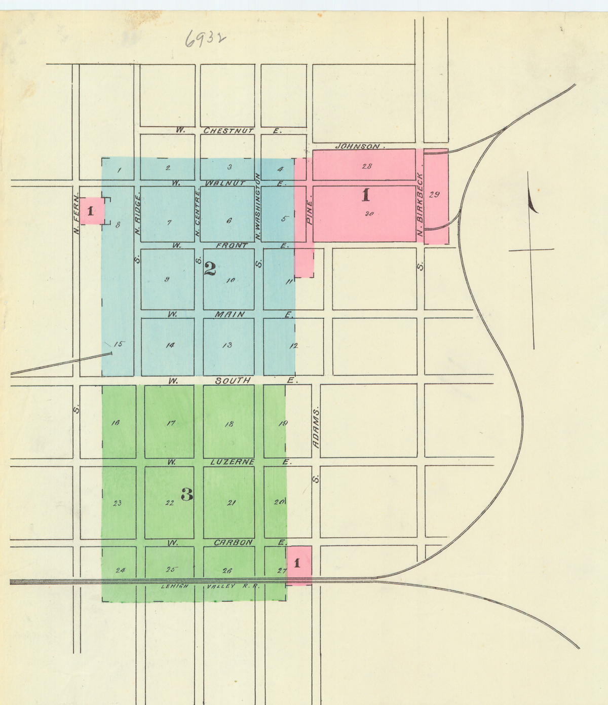
right is an overview of the town from the first map sheet, showing
which parts of
town are depicted on which maps. In 1895 the Freeland
Sanborn map is on 3 map sheets; by 1912 it took 8 map sheets. In 1895,
you see that
Freeland had grown from its original layout in 1870, with a good deal
of expansion south of Front street, and some along Birkbeck street,
along with the addition of St. Mary's Byzantine Catholic Church on
upper Fern street. The big annexations of Birvanton, South Heberton,
Alvinton, and the Woodside or Coxe Addition were just a year or two
away. Notice the rail lines shown on this overview. One small spur goes
to the location of the Freeland brewery, while another goes up to the
feed mill and the power and electric utility.
The image at left
is the map legend, giving the title of the map, some descriptive
information, and an index of certain buildings that are labeled on the
map. As you'll see, the focus is on vulnerability
to
and protection from fire, so there is
information on the legend about Freeland's water
facilities and fire department, and as shown in the illustration key
there is also information given about what the various buildings were
constructed of, suggesting how flammable they would be or how well they
might withstand a fire. The image at
right is an overview of the town from the first map sheet, showing
which parts of
town are depicted on which maps. In 1895 the Freeland
Sanborn map is on 3 map sheets; by 1912 it took 8 map sheets. In 1895,
you see that
Freeland had grown from its original layout in 1870, with a good deal
of expansion south of Front street, and some along Birkbeck street,
along with the addition of St. Mary's Byzantine Catholic Church on
upper Fern street. The big annexations of Birvanton, South Heberton,
Alvinton, and the Woodside or Coxe Addition were just a year or two
away. Notice the rail lines shown on this overview. One small spur goes
to the location of the Freeland brewery, while another goes up to the
feed mill and the power and electric utility.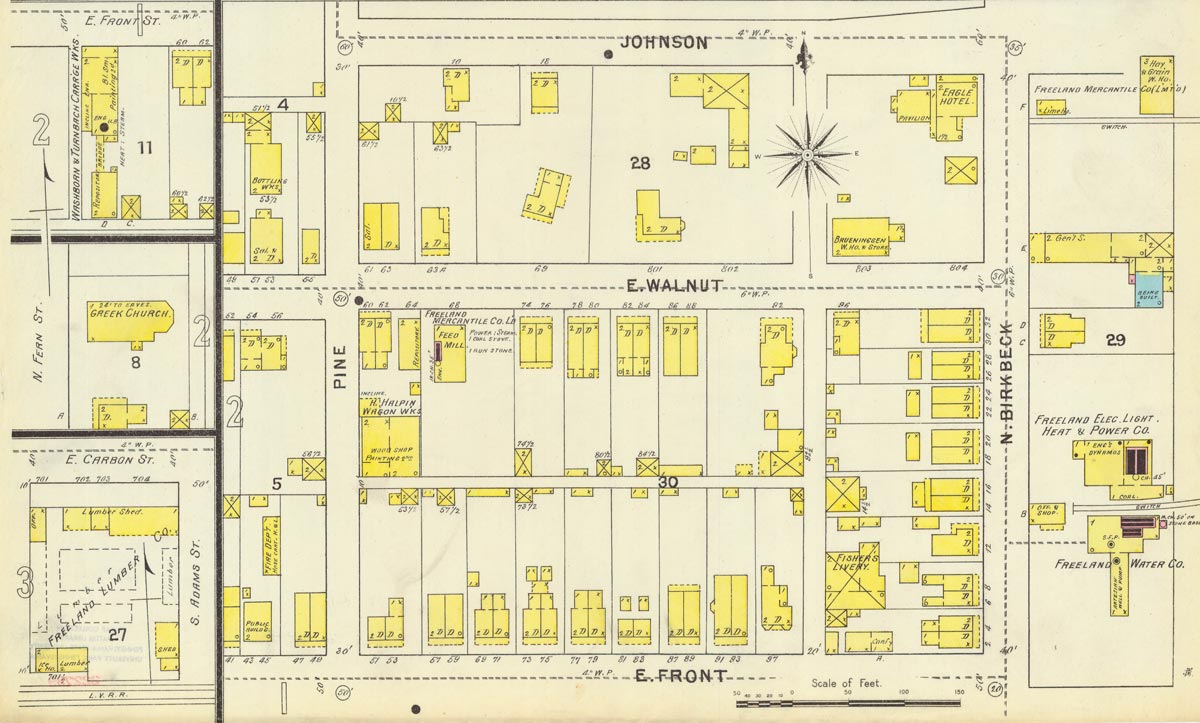 The first map
sheet shows the northeast corner of the
town at the time, the northeast corner being the area between Johnson
and Front streets, bounded on the east by Birkbeck street and on the
west by Pine street and another half block past that. A few additional
details are tacked onto this map, showing several buildings that are
outside the bounds of the 1895 map sheets: the Washburn and Turnbach
Carriage Works, St. Mary's Church, and the Freeland Lumber Company.
The first map
sheet shows the northeast corner of the
town at the time, the northeast corner being the area between Johnson
and Front streets, bounded on the east by Birkbeck street and on the
west by Pine street and another half block past that. A few additional
details are tacked onto this map, showing several buildings that are
outside the bounds of the 1895 map sheets: the Washburn and Turnbach
Carriage Works, St. Mary's Church, and the Freeland Lumber Company.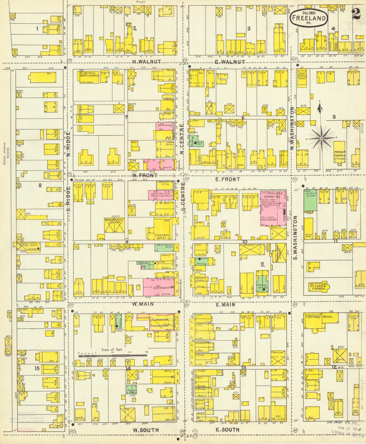 The second map
sheet shows the main section of town above South street, from a half
block east of Washington street to a half block west of Ridge street.
Most of the business district is shown on this map. Businesses are
labeled by type, such as "D.G." for dry goods, "Confec." for
confectionary, "Gro." for grocery, "Sal." for saloon, and so on. In a
few cases, buildings are actually labeled by name, such as "Hunsicker
Livery," "Freeland Opera Ho.," "Presb'n. Church." Some, but not all, of
those are also listed in the index on the map legend. Notice the
variation in the sizes of lots, and how most properties also contain
small outbuildings. Buildings that were unoccupied when the map was
made are labeled "Vac." for vacant. Note that the Cottage Hotel was
already built in 1895.
The second map
sheet shows the main section of town above South street, from a half
block east of Washington street to a half block west of Ridge street.
Most of the business district is shown on this map. Businesses are
labeled by type, such as "D.G." for dry goods, "Confec." for
confectionary, "Gro." for grocery, "Sal." for saloon, and so on. In a
few cases, buildings are actually labeled by name, such as "Hunsicker
Livery," "Freeland Opera Ho.," "Presb'n. Church." Some, but not all, of
those are also listed in the index on the map legend. Notice the
variation in the sizes of lots, and how most properties also contain
small outbuildings. Buildings that were unoccupied when the map was
made are labeled "Vac." for vacant. Note that the Cottage Hotel was
already built in 1895.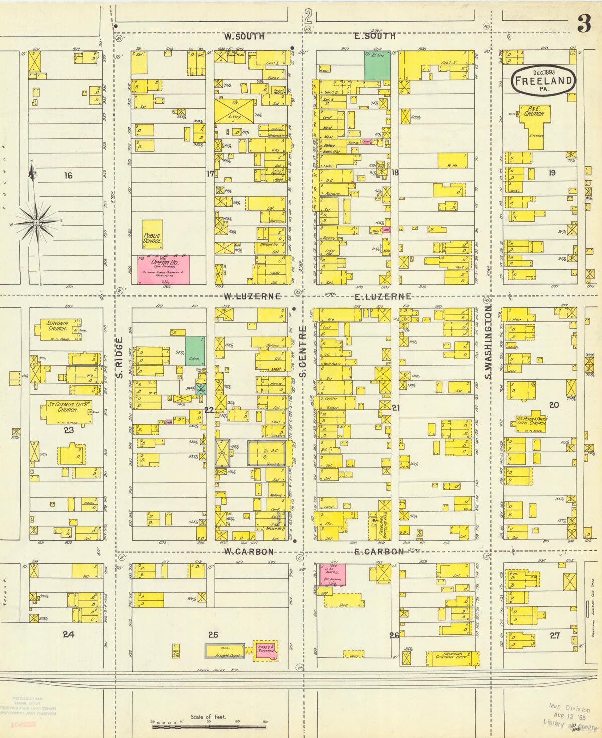 The third
map sheet is a continuation
of section 2, showing the main area of town below South street. The
town is bounded on the south by the railroad tracks. Note the second
opera house at Ridge and Luzerne streets, which later became a silk
mill and now is an apartment building. Just next to that is one of the
public schools, a building now owned by the Belekanich family.
Diagonally
across the street is the original site of St. John's Nepomucene Roman
Catholic Church, with St. Casimir's (mislabeled St. Cosmus) just down
the street. Two blocks to the east is St. Peter and Paul's Slovak
Lutheran Church. The train station and freight depot are on Centre
street below Carbon.
The third
map sheet is a continuation
of section 2, showing the main area of town below South street. The
town is bounded on the south by the railroad tracks. Note the second
opera house at Ridge and Luzerne streets, which later became a silk
mill and now is an apartment building. Just next to that is one of the
public schools, a building now owned by the Belekanich family.
Diagonally
across the street is the original site of St. John's Nepomucene Roman
Catholic Church, with St. Casimir's (mislabeled St. Cosmus) just down
the street. Two blocks to the east is St. Peter and Paul's Slovak
Lutheran Church. The train station and freight depot are on Centre
street below Carbon.