News & announcements
Saving your history
Early accounts
Maps
Nearby towns
People
Churches
Schools
Municipal
Organizations
Businesses
The mines
Transportation
Streets
Buildings
Entertainment
Celebrations
Sports
Ethnic groups
Freeland maps
What's on this page about Freeland:
- 1870 map of Freehold
- 1873 map of Freehold
- 1896 map of proposed annexation of Alvinton, Birvanton and South Heberton to Freeland
- Undated map of the
Woodside Addition to Freeland (also
known as the Coxe Addition)
- 1895 Sanborn map of Freeland, along with links
to
later
Sanborn maps
- 1939 map of Freeland, annotated
- Freeland address numbering
The original name of the town that became Freeland was Freehold. But when the borough was incorporated in 1876, it was with the name of Freeland. In his book on Freeland history, Charles Stumpf tells the story:
... A meeting was called in town hall. It was a long affair with much discussion and the presentation of many ideas and opinions. Postmaster Luther Dodson pointed out that there was already another town bearing the name 'Freehold' within the postal district. So the selection of a new name became the order of business. After much deliberation Mr. Manus Conaghan stood up and declared: "Gentlemen. I do not believe that we are getting anywhere and there is no use discussing this problem all night. Since we cannot seem to agree on a complete new name, why can't we change just a part of it? I move that we change just the last part and call the town Free-LAND."
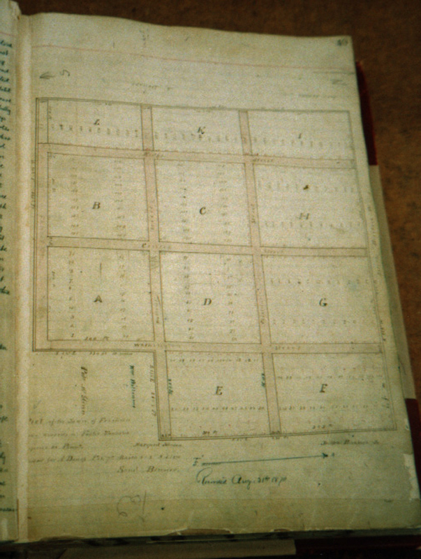
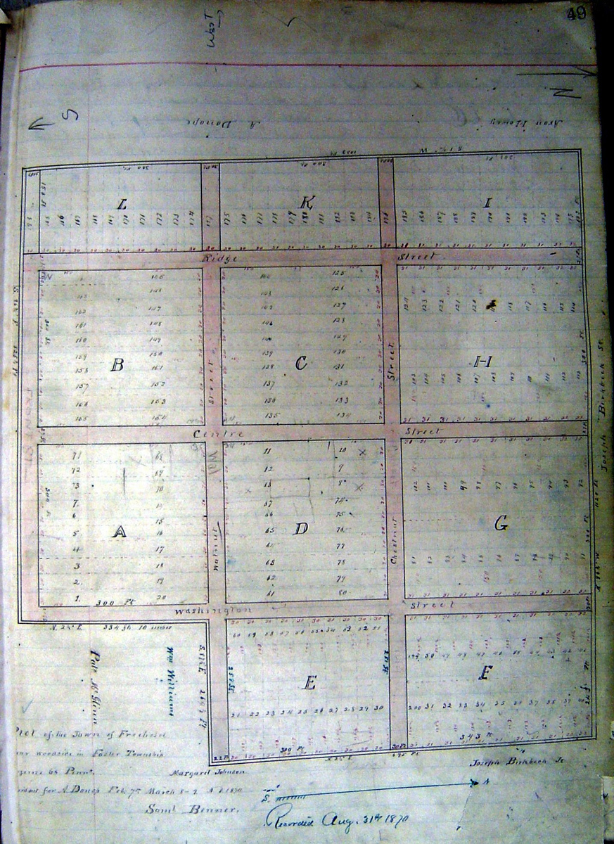
1870 Plot of the town of Freehold
 Originally called Freehold, our town was
founded by August Donop, who
purchased the land in 1868 and had the plot of the town laid out and
recorded by 1870. The first recorded map that I know of is
this one, found in a volume at
the Luzerne County Courthouse. The day I looked at it, I took this
dismal photo (far left) with the poor camera that I had with me at the
time.
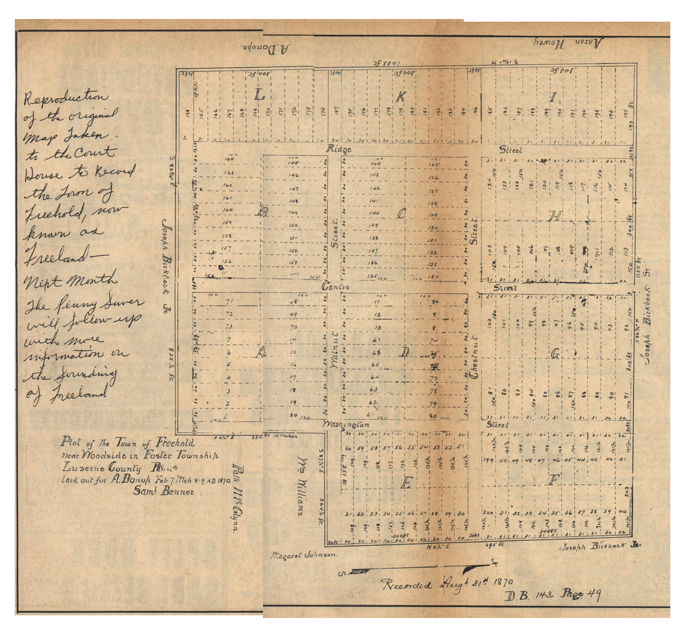
Later, Christina Humphreys was there doing research and she kindly
shared some of what she found with me, including a better photo of the
map (left). Thank you, Christina! In Freeland
Pennysaver issue no. 2(6),
August 1964, a redrawn copy of this map was reproduced. I have it in
two pieces, and please forgive my inexpert joining of them (right).
Originally called Freehold, our town was
founded by August Donop, who
purchased the land in 1868 and had the plot of the town laid out and
recorded by 1870. The first recorded map that I know of is
this one, found in a volume at
the Luzerne County Courthouse. The day I looked at it, I took this
dismal photo (far left) with the poor camera that I had with me at the
time.
Later, Christina Humphreys was there doing research and she kindly
shared some of what she found with me, including a better photo of the
map (left). Thank you, Christina! In Freeland
Pennysaver issue no. 2(6),
August 1964, a redrawn copy of this map was reproduced. I have it in
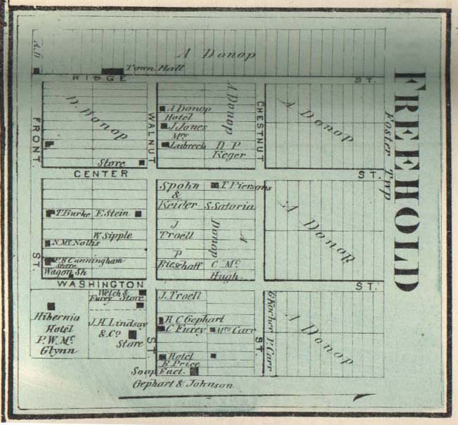
two pieces, and please forgive my inexpert joining of them (right).In 1870 this map was recorded at the Luzerne County Court House to show the layout of a proposed new town. The notes on the map say: “Plot of the Town of Freehold near Woodside in Foster Township, Luzerne County, Penna., laid out for A. Donop Feb. 7 – Mch. 8-9, 1870. Saml. Benner.” The map was recorded at the Court House on August 31, 1870. The shape of the new town was nearly square, minus one corner at the southeast end. There were three streets running east and west (Front, Walnut, Chestnut) and three running north and south (Ridge, Centre, Washington). The town was bordered by various pieces of property owned by Joseph Birkbeck, Sr., Joseph Birkbeck, Jr., Aaron Howey, A. Donop, Margaret Johnson, William Williams, and Patrick McGlynn. The north border of the town was measured at 1,120 feet, the west border at 1,033 feet, the south border up to the “missing corner” of the square-shaped plot at 825-1/2 feet, the east border down to the “missing corner” at 695 feet, and the two sides of the “missing corner” at 264-1/2 feet and 334 feet 10 inches. There were five blocks containing 20 lots each, three containing 22 lots each (the blocks along the north part of town), and one long “block” along Ridge Street that ran the entire length of the west side of town and contained 33 lots.
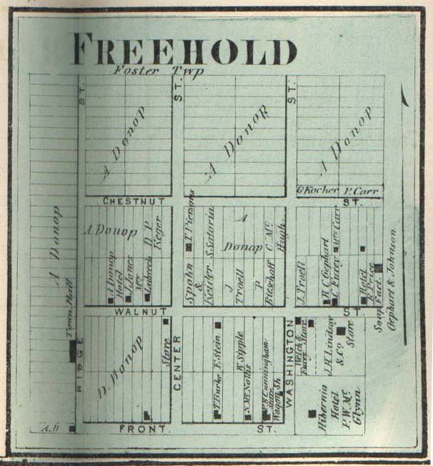
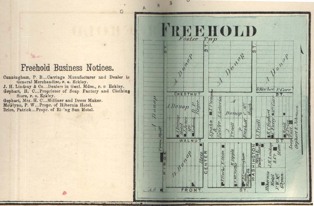
1873 Map of Freehold from 1873 Atlas of Luzerne County
 Three years later
this map appeared in
the 1873 Atlas of Luzerne
County. Little more than nine blocks square, the town had six
streets
and about two dozen buildings. The shape of the
town was unchanged, except that
the “missing corner” at the southeast end was now filled in with lots
containing several businesses, in the area where the Freeland Water
Works are now located. No new streets are recorded yet, and
the area above the northern border is labeled “Foster Township.” The
view at right has been rotated so it's easier to read.
Three years later
this map appeared in
the 1873 Atlas of Luzerne
County. Little more than nine blocks square, the town had six
streets
and about two dozen buildings. The shape of the
town was unchanged, except that
the “missing corner” at the southeast end was now filled in with lots
containing several businesses, in the area where the Freeland Water
Works are now located. No new streets are recorded yet, and
the area above the northern border is labeled “Foster Township.” The
view at right has been rotated so it's easier to read.Alongside the 1873 map are listed six businesses:
Cunningham, P. G. – Carriage Manufacturer and Dealer in General Merchandise, P.O. Eckley
 J. H. Lindsay & Co. – Dealers
in General Merchandise, P.O. Eckley
J. H. Lindsay & Co. – Dealers
in General Merchandise, P.O. EckleyGephart, H. C. – Proprietor of Soap Factory and Clothing Store, P.O. Eckley
Gephart, Mrs. H. C. – Milliner and Dress Maker
McGlynn, P. W. – Propr. of Hibernia Hotel
Brice, Patrick – Propr. of Rising Sun Hotel
There were also at least two more businesses and one more hotel shown on the map but not included in the list printed next to it.
Let's take a few minutes to imagine this early version of Freeland. The blocks between Front and Chestnut Streets were oriented so that the lots fronted onto the streets running east and west. Those above Chestnut and those to the west of Ridge were oriented so that the lots fronted onto streets running north and south. Most of the businesses were located on Front and Walnut Streets. It has been reported that A. Donop envisioned Walnut Street as being the main street of the town, and indeed most of the occupied lots in 1873 were along Walnut Street, with Front Street having the second largest number of occupied lots. At this time, at least as far as the map shows, Front Street was the southern boundary of town, and no lots or buildings are shown along the southern side of Front Street.
People walking along Front Street in 1873 would have passed a number of undeveloped lots, a couple of properties belonging to T. Burke and Noltis, and the P. G. Cunningham Store and Wagon Shop near the southwest corner of Front and Washington. Turning up Washington Street from Front, they would see on the east side of Washington (in what had been the “missing corner” on the 1870 map) several businesses between Front and Walnut: the Hibernia Hotel, run by Patrick W. McGlynn; the Welch & Furey Store, and the J. H. Lindsay & Co. Store. These last two stores fronted onto Walnut Street east of Washington.
Across the street from the J. H. Lindsay & Co. Store and a little to the east were the Rising Sun Hotel, run by P. Price (or Brice) and the Soap Factory run by Gephart and Johnson. People passing those businesses and then walking west on Walnut Street would have passed lots owned by W. Sipple and E. Stein on the south side of the street (along with a number of empty lots), and on the other side they would see lots owned by C. Furey, H. C. Gephart, J. Troell, P. Riesehoff, Spohn & Keider, Lubrech, J. Jones, and what is marked on the map as A. Donop Hotel.
A large town hall is shown on the west side of Ridge Street, between Front and Walnut. A smaller building is on the southwest corner of Ridge and Front Streets. All other lots along the west side of Ridge Street belonged to A. Donop in 1873, and were undeveloped.
People walking along Chestnut Street from Ridge Street heading east would have been on the outer edge of Freehold. Many lots on the south side of Chestnut Street were undeveloped, but some properties were owned by D. P. Keger, T. (or P.) Piersons, S. Sataria, C. McHugh, and Mrs. Carr. Other properties are marked A. Donop. Only a few of those properties mentioned contained buildings at the time the map was made. On the north side of Chestnut Street, all of the property still belonged to A. Donop and was undeveloped, except the two lots furthest east on Chestnut Street’s north side, belonging to G. Rocher and P. Carr.
So the 1873 map shows only 22 buildings in Freehold, with a number of other properties spoken for but not yet developed, and quite a few lots still held by A. Donop. Three years later, the name of the town was changed to Freeland and Freeland was incorporated as a Pennsylvania borough on September 11, 1876.
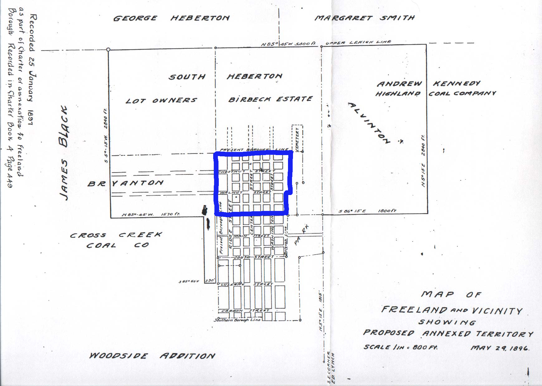
1896 Map of proposed annexation of Alvinton, Birvanton and South Heberton to Freeland
Twenty years after its incorporation, the size and shape of the town had increased dramatically. A map recorded in 1897 documents the annexation of South Heberton, Alvinton and Birvanton, which basically added everything that now lies on either side of the original borders north of Front Street. This map in the Luzerne County Courthouse in Wilkes-Barre shows the proposed annexation of ‘Alvinton’, ‘Birvanton’, and ‘South Heberton’. The map shows a somewhat larger Freeland, extending from just south of what is now North Street down to just below Carbon Street, and from a line between Ridge and Fern Streets on the west to a border just east of Washington Street on the east. Actually, the map is also a bit confusing, because it shows one southern borough line going through South Street, and a second “Southern Borough Line” just below Carbon Street. This seeming contradiction is not explained on the map. I'll add, though, that the business listings in 1895 and 1897 show an evolution in Freeland's development, as businesses in that area below South Street didn't yet have building numbers in 1895 -- saying things like "Carbon near Ridge" for an address -- but they do in 1897.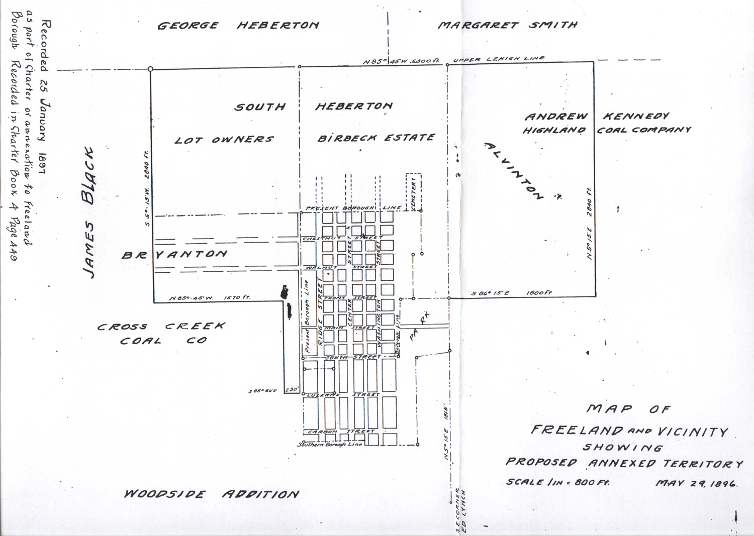 This map shows the Alvinton
section to the east and northeast, South
Heberton to the north and northwest, and Birvanton to the west of town.
These are names that we don't use anymore, but as Charles Stumpf has
reported, Alvinton was named in honor of Alvin Markle, South Heberton
was said to have been named for George Heberton, and Birvanton was
"Bir-Van-Ton Hill,” the name referring to three families who lived
there, the Bird, Evans and Burton familes. The name was coined by young
Levi Bird, son of Rev. George Bird, the first pastor to serve the
Methodist church in Freeland. The text at the bottom of the map says
“Map of Freeland and Vicinity Showing Proposed Annexed Territory, Scale
1 in. = 800 ft., May 29, 1896.” Another notation reads: “Recorded 25
January 1897 as part of Charter of annexation to Freeland Borough,
Recorded in Charter Book 4, page 449.”
This map shows the Alvinton
section to the east and northeast, South
Heberton to the north and northwest, and Birvanton to the west of town.
These are names that we don't use anymore, but as Charles Stumpf has
reported, Alvinton was named in honor of Alvin Markle, South Heberton
was said to have been named for George Heberton, and Birvanton was
"Bir-Van-Ton Hill,” the name referring to three families who lived
there, the Bird, Evans and Burton familes. The name was coined by young
Levi Bird, son of Rev. George Bird, the first pastor to serve the
Methodist church in Freeland. The text at the bottom of the map says
“Map of Freeland and Vicinity Showing Proposed Annexed Territory, Scale
1 in. = 800 ft., May 29, 1896.” Another notation reads: “Recorded 25
January 1897 as part of Charter of annexation to Freeland Borough,
Recorded in Charter Book 4, page 449.” Also shown on this map are the Public Park and the Freeland Cemetery. The overall expanded area depicted on the map is surrounded by properties owned by James Black, George Heberton, Margaret Smith,
 Andrew
Kennedy, Highland Coal Company, and Cross Creek Coal Company.
South Heberton is divided on the map between the Birkbeck estate
(eastern half) and other lot owners (western half). A “Woodside
Addition” is also noted, but not shown, to the southwest of town.
Andrew
Kennedy, Highland Coal Company, and Cross Creek Coal Company.
South Heberton is divided on the map between the Birkbeck estate
(eastern half) and other lot owners (western half). A “Woodside
Addition” is also noted, but not shown, to the southwest of town.The proposed annexation documented by this map would approximately quadruple the size of Freeland. At right, I drew the approximate "footprint" of the original Freehold in blue on this copy of the the annexation map to show how much the town was growing in this period.
Undated Map of the Woodside Addition to Freeland (also known as the Coxe Addition)
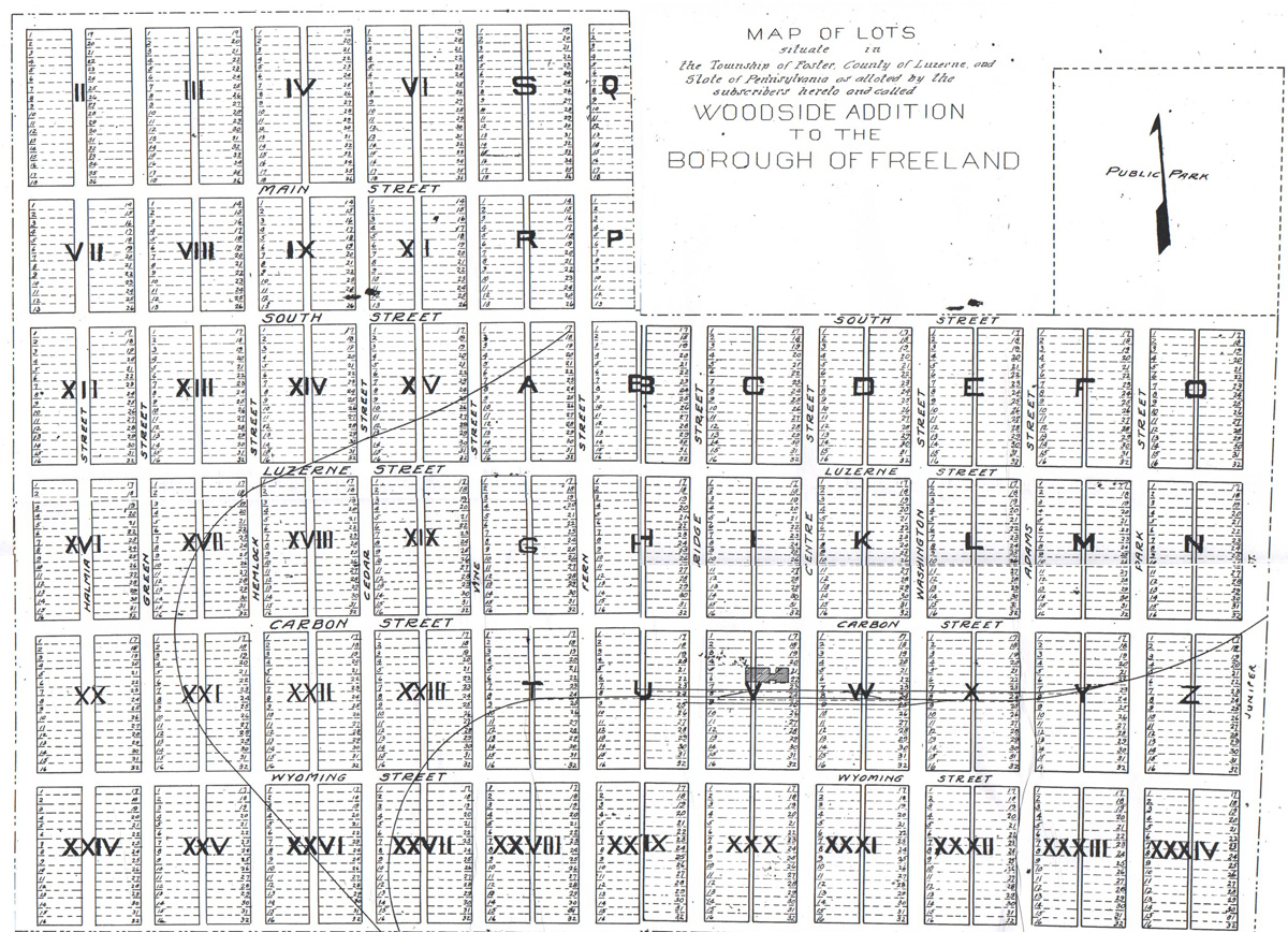 Another map
from
the same period records the Woodside addition to the borough of
Freeland, which extended the town south of South Street, from Juniper
Street on the east to just beyond Green Street on the west. It also
added the section of town west of Ridge Street from School Street (then
called West Front Street) down to below Wyoming Street. Some of the
lots in this addition would remain officially outside the borough line
in Foster Township, but in effect between this addition and the
annexation described above, the town increased by several
times its original size in a relatively short period of time.
Another map
from
the same period records the Woodside addition to the borough of
Freeland, which extended the town south of South Street, from Juniper
Street on the east to just beyond Green Street on the west. It also
added the section of town west of Ridge Street from School Street (then
called West Front Street) down to below Wyoming Street. Some of the
lots in this addition would remain officially outside the borough line
in Foster Township, but in effect between this addition and the
annexation described above, the town increased by several
times its original size in a relatively short period of time. Notice the two rail lines, one going to the old Freeland train depot and beyond, the other passing near the old stone quarry and going to the Freeland Brewery.